After completing Australia entry formalities at Cairns (they made me dispose of all my eggs and meat for “Biosecurity”), my next challenge was to sail north, cross the Great Barrier Reef (GBR), then sail west through the Torres Strait, a collection of narrow waterways connecting the Pacific and Indian Oceans.
From Cairns many yachts follow the inside route to the Torres Strait along the Queensland coast. This foute is also an active shipping channel and full of islands and reefs. For me, sailing solo, it’s a poor choice because I would have to stop and anchor somewhere every night to get some sleep. I’m much more comfortable far offshore where there’s nothing to run into and I can let the autopilot drive the boat while I sleep.
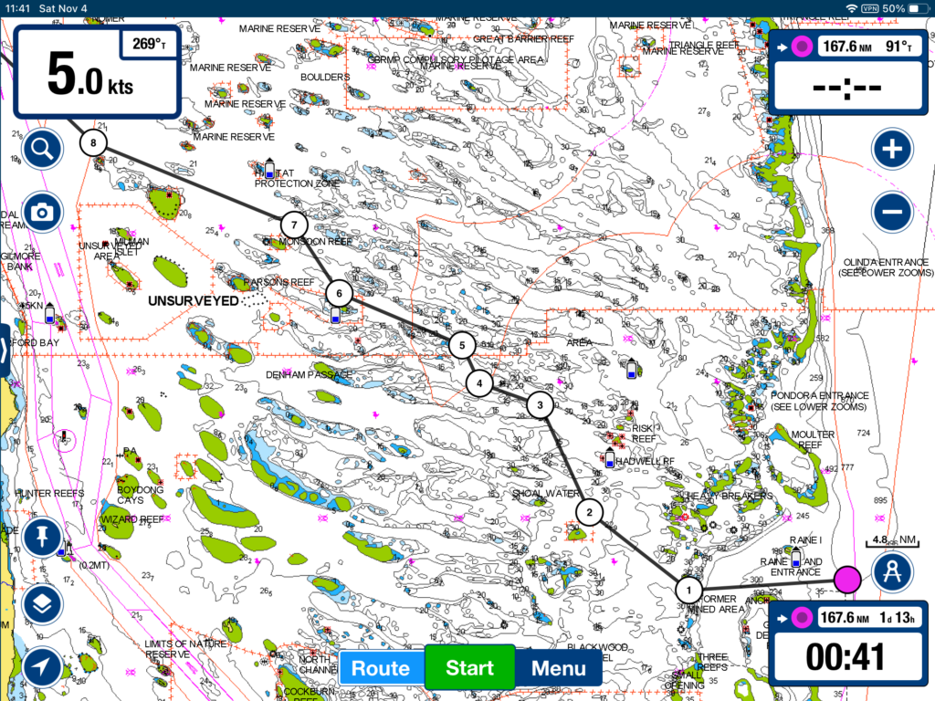
Leaving Cairns I went back outside the reef at Grafton Passage and turned straight north to Raine Island, 350 nm away, the point where I would start my passage across the GBR. I first learned about this route from a book published some years by Ken Hellewell. The route he describes in the book is very detailed with more than 30 GPS waypoints. After studying the charts I decided I could come up with something much simplier that worked as well. I chose route legs by trying to stay in water that was at least 20 meters deep. As I sailed this route, in fact, the shallowest depth I saw on the depth sounder was 19 meters. As a point of reference, that’s more than deep enough to handle a hugh cruise ship. The Cairns Channel which routinely handles such big ships is only dredged to a depth of 12-13 meters. If someone were to accept charted depths as shallow as 10 meters, my route across the GBR could be simplified still further.
I set up my route waypoints in the chartplotter on the boat and instructed the autopilot to drive the whole thing, which it did perfectly. I only had to adjust the sails when the course direction changed. Because the winds were light (10-12 kts), I motorsailed part of the route to make sure I could get past the trickiest parts during daylight after starting from Raine Island at about 0730.
Waypoint 8 sits on a red line which marks the edge of the inside shipping channel so at that point I was home free regarding any reef hazards. You’ll also see at waypoint 1 a note that says “FORMERLY MINED AREA”. Hitting a forgotten WW2 mine and getting blown to bits would have been a spectacular conclusion to my voyage!