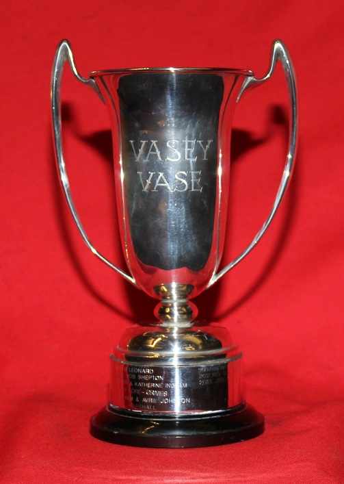
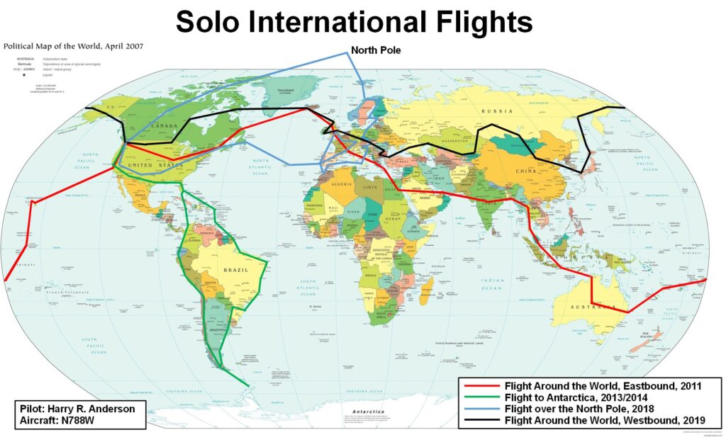
Last week I was notified that I have been awarded the 2025 OCC Vasey Vase Award recognizing an unusual or exploratory voyage made by one of its members. It’s not awarded every year but only when a voyage is significant enough to qualify. I was very surprised by this news.
Someone I don’t know wrote:
“In nominating Harry for the Vasey Vase in 2025 I ask you to consider his unique achievement in emulating a previous feat of flying solo to seven continents and by then undertaking a single-handed sailing voyage to the same seven continents. Having already become only the fifth person to fly solo to all seven continents, the completion of the subsequent solo voyage turned the achievement into a world record worthy of the OCC Vasey Vase Award.”
I will travel to Edinburgh, Scotland, for the awards dinner on April 18.
I was last in Edinburgh three decades ago but still feel acquainted with the place through Ian Rankin’s series of police/crime novels set there featuring sardonic, chain-smoking detective John Rebus. While investigating an apparent suicide of someone jumping off a castle wall during a military ceremony, complete with bagpipes, Rebus commented “Maybe the sound of the pipes broke his will to live.” Ha! Good books.
Founded in 1954 and based in the UK, the Ocean Cruising Club is the premier international organization for ocean-going sailors with more than 3,700 members in 85 countries. www.oceancruisingclub.org
My Dad was a radioman in the Navy in WWII, flying on patrol bombers searching for German submarines off the coast of Brazil and later over the English Channel. He flew out of an airfield at the small English village of Dunkeswell, a place I flew into myself in my around-world-flight in 2011. He had become a ham radio operator as a teenager in the 1930’s so being a radioman in the Navy was a natural fit. Morse code to him was a second language and part of the soundtrack of my childhood.
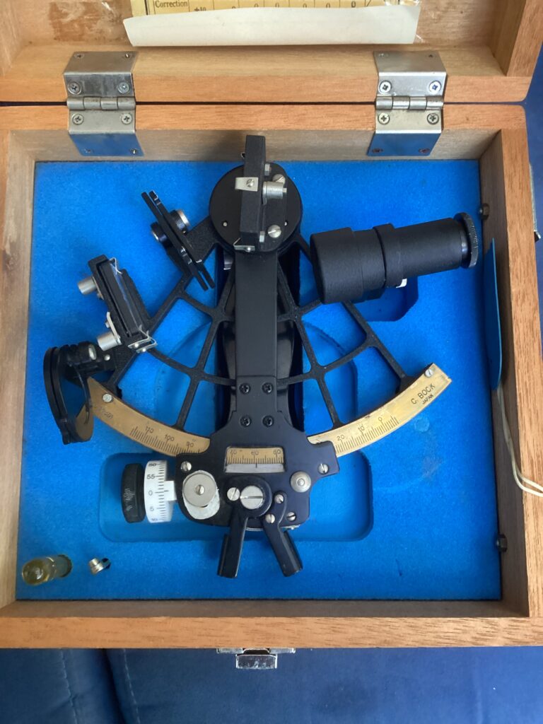
He had a long career in broadcast engineering, ultimately becoming VP of Engineering at KCET, the PBS televsion station in Los Angeles. He retired early to pursue a long-held dream to sail the world’s oceans with my Mom. As a retirement gift the PBS executives gave him this sextant.
They bought a suitable boat, moved on board, and started sailing along the California coast in preparation for bigger things. In 1980 they started sailing south along the Baja peninsula. They were a thousand miles into their voyage when my Mom discovered a lump in her neck. They suspended their voyage and flew back to San Diego to have it evaluated. It was cancer. My Mom put up a valiant fight, still living on the boat which was brought back to San Diego by a delivery skipper, but passed away in 1986.
My Dad sold the boat, eventually got re-married, and bought a house in Vista, California. This sextant was prominently displayed on a wall in the house. When my Dad passed away in 2005 the sextant was handed on to me.
I’ve carried my Dad’s sextant with me everywhere I’ve sailed for the past 2 1/2 years, across the world’s oceans, to seven continents, several countries and dozens of harbors and anchorages around the globe. In this small way they were along with me, sailing the world as they once dreamed of doing. I think they would have liked that.
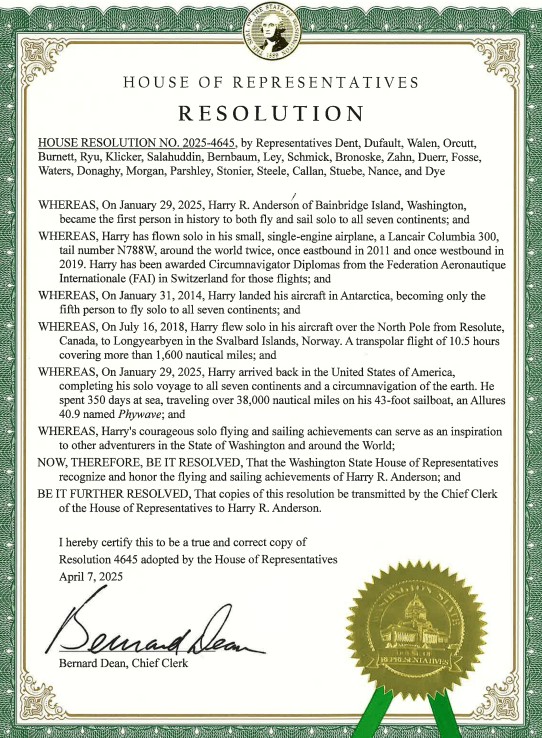
With my arrival today, January 29, 2025, in Fort Lauderdale (my North America landing), I have completed my solo voyage to 7 continents and become the first person to both fly and sail solo to all the continents. There aren’t any official records, and I don’t know what solo sailors have done over the years in terms of sailing to all the continents. However, I do know the few other solo pilots who have landed on all the continents. None of them are offshore sailors so I’m pretty sure I’m the first person to do both.
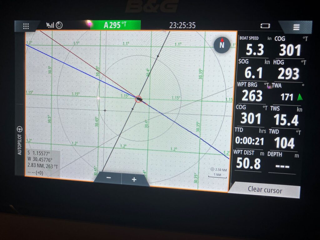
It’s a seemingly insignificant longitude except for me. Crossing it today, January 20, 2025, at 0928z marks the completion of my solo circumnavigation. I’ve now sailed around the world, crossing all the meridians and the equator.
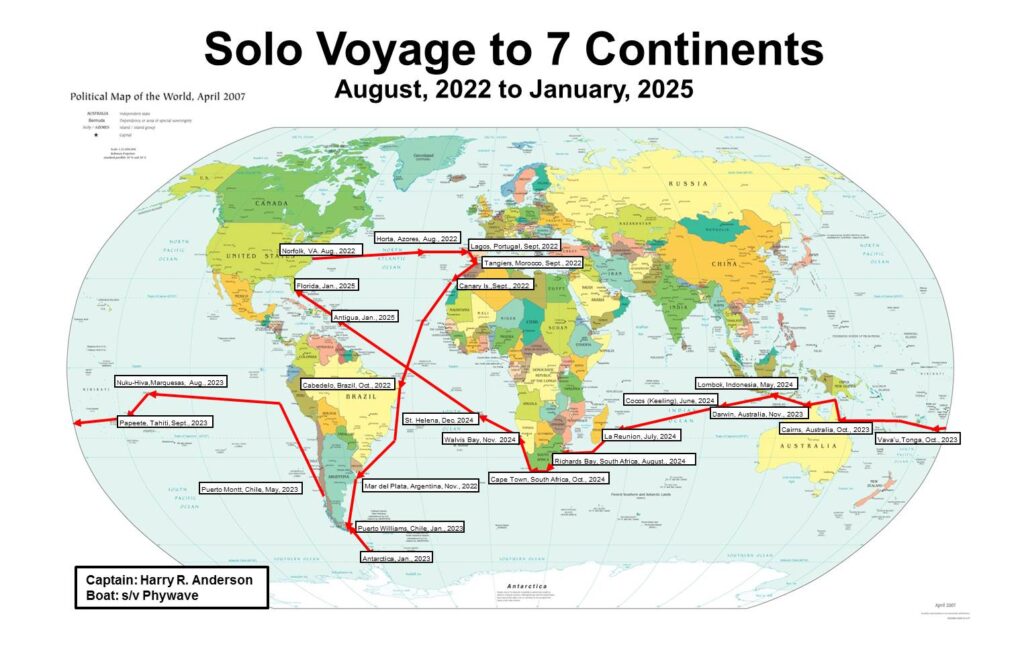
Some may wonder why that didn’t happen when I crossed the longitude of Tangiers, my farthest excursion east in 2022. Those of you who have followed my voyage recall I took a break at home after successfully sailing to Antarctica and back. During the break I had a crew from Puerto Williams in Chile deliver Phywave through the difficult channels of Patagonia to Puerto Montt. When I returned to Chile, I resumed my solo voyage from the Reloncavi Yacht Club marina in Puerto Montt. The longitude of that marina is 78.9875 degrees West Longitude so it marks the beginning of my solo circumnavigation. I’ve now completed the circumnavigation by crossing that longitude again. Even though I didn’t return to my starting point, it’s still considered a circumnavigation.
In my last post I explained that the port side autopilot drive unit on my boat had failed, something I only realized when I disengaged the AP and tried to manually steer the boat upon arriving in Antigua. I was able to find a new replacement drive unit and get it to Antigua but I decided not to install it. Removing the failed unit and installing the new one would have been a fair amount of work in a tight space in an aft compartment of my boat. In diagnosing the original problem, I also figured out I could make the starboard side AP completely independent of the port side AP so it can successfully steer the boat on its own. There was also a favorable weather window opening on January 15 for sailing north I wanted to hit which didn’t leave me time to install the new drive unit. I’ll wait to replace the failed unit until I get to Florida. It means I’m now sailing with only one working AP but most boats only have one AP anyway. Having a backup AP was a luxury I wanted when I ordered Phywave back in 2020. It turns out I needed it.
I’m now en-route from Antigua to Rock Sound on Eleuthera Island in the Bahamas. I expect to arrive there on Wednesday.
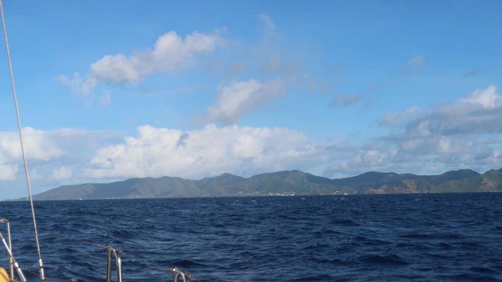
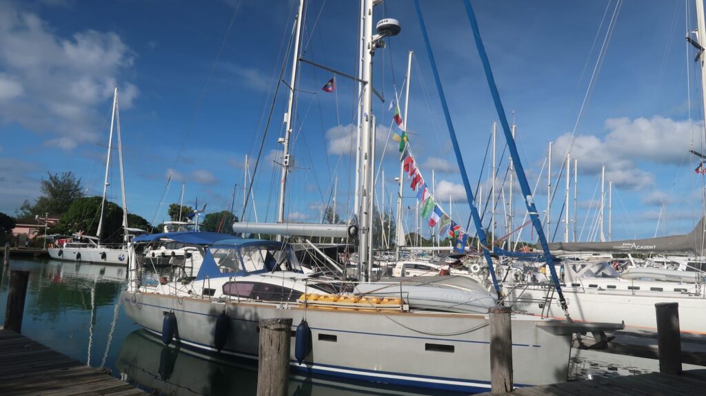
Conch fritters, stormy cocktails and a great reggae band at the Sea Dream restaurant was a pretty good first night in Jolly Harbour after a 4,000 nm, 30 day passage from St. Helena Island in the South Atlantic.
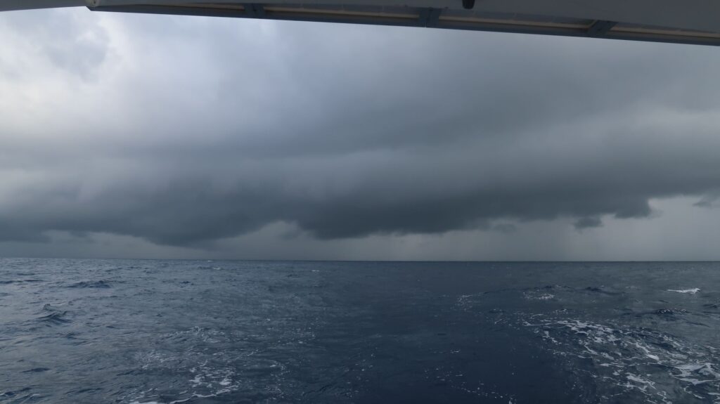
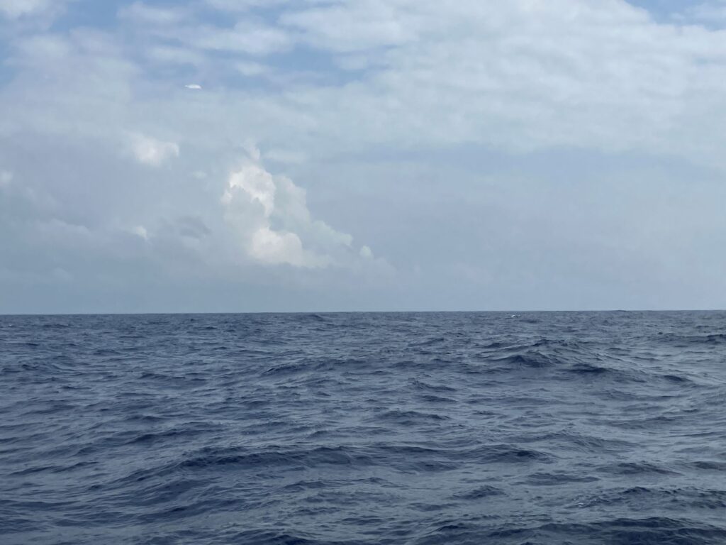
The first half of the passage, south of the equator, was sublime with solid following winds and sunny skies. Crossing the equator into the InterTropical Convergence Zone (ITCZ) the weather became cloudy with occasional rain squalls, one of which accelerated the wind from 15 kts to 40 kts, and change direction by 40 degrees, in less than 2 minutes. Fortunately, that one occurred during the daytime and I saw in coming, confirmed its location and approach speed on radar, and was able to reduce sails in preparation for it hitting me. If a squall comes at night when I’m trying to sleep it will usually be a big surprise causing me to quickly scramble out of the rack and get on deck to reduce sails.
North of the equator there are also strong, looping currents that retarded my progress. The weather forecast showed a large area of very little wind along my direct route (about 300 degrees true) from St. Helena to Antigua. I had to divert west from that to avoid the worst of the “no wind” zone. Still, I had single digit wind speeds for a few days and was lucky to get 4 kts boat speed. When you’re trying to get passed a crossing current of 2 kts with slow boat speed it results in a lot of crabbing, sometimes up to 30 degrees. It’s miserable sailing. I finally ran the engine for 6 hours to get out of the last of the strong crossing currents. The wind eventually picked up and I had a reasonably fast remaining week into Antigua although the 1-2 meter waves were right on the beam of the boat causing a lot of rolling and an uncomfortable ride.
Finally motoring into Jolly Harbour, I disengaged the autopilot (AP) and was shocked to discover my manual steering range at the helm was greatly reduced to about +/- 10 degrees from the normal range of +/- 35 degrees. I was barely able to steer the boat enough to dock by the immigration and customs office. Once I had completed the clearing-in process I was faced with getting my boat into my berth at the marina, typically requiring a lot of tight turns and full rudder steering range and the bow thrusters. I called the marina dockmaster on the VHF and explained my problem. With his help and another guy, we finally got the boat passed the tight turn into my berth.
Needless to say, I can’t leave Antigua with this steering problem. Once tied up in my berth, I started taking things apart. My boat has 2 rudders, 2 steering wheels (one connected to each rudder), 2 AP computers (one as a backup) and 2 AP drive units which convert the signals from the AP computer into the “muscle” needed to actually move the rudder. There is a heavy steel bar that connects the rudders to always keep them in sync. After disconnecting the mechanical components, it was clear the port side drive unit had failed such that it restricted the rudder range of motion. Once I disconnected that drive unit from the rest of the steering system I had my full range of steering back. It’s unlikely I can fix it so it looks like a replacement is needed. Sourcing it, getting it to Antigua, and installing it will be a challenge.
I thought my stop in Antigua would be a holiday but it seems an offshore sailboat is a demanding taskmaster never relenting on what’s required to keep it going.
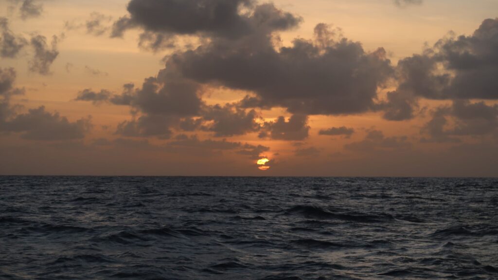
A rain squall bearing down on me.Sunset after a stormApproaching Antigua from the southPhywave in the Jolly Harbour Marina. I decided to string up all the courtesy flags for the places I’ve visited on this voyage.
I’ve crossed the Equator twice now, once southbound more than 2 years ago and northbound again yesterday. You’d think there’d be a big dashed line like you see on globes and world maps but nope, nada! In the old days, before GPS, we would mark our position by painting a spot on the water. Alternately, you could paint a spot on the side of the boat. Either way, you’d know one thing or another.
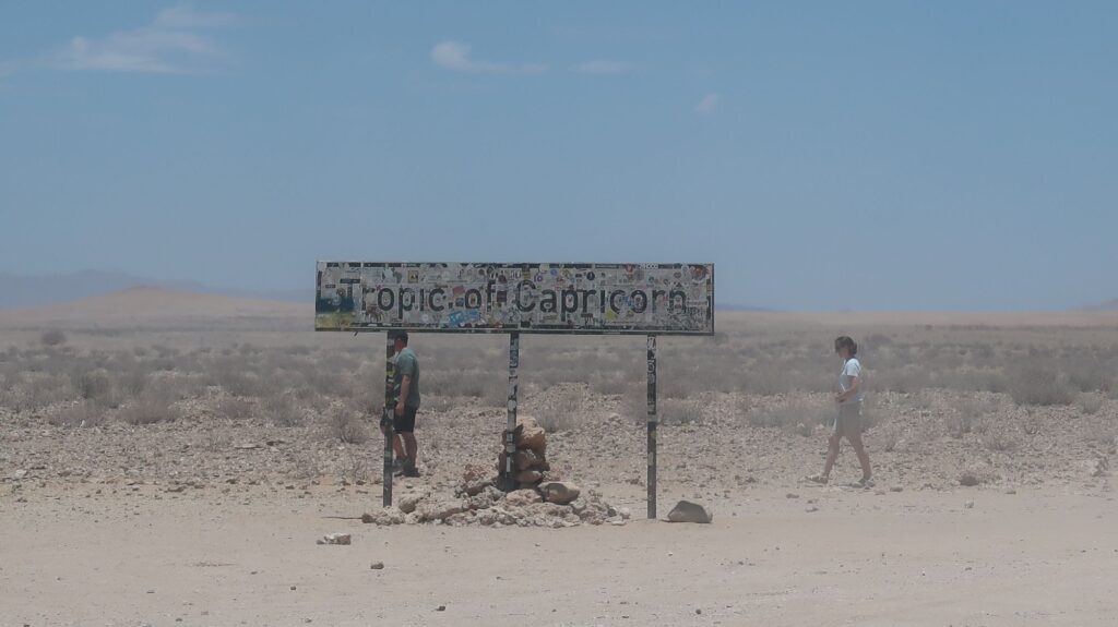
Of course, nobody precisely knows where equator is because zero degrees latitude (the Equator) is a made-up thing. That will come as some disappointment to people who build stone monuments with bronze plaques that say “Dude, you’re standing on the Equator”. I passed a sign by the gravel road in Namibia that said “Tropic of Capricorn” like they knew where it was. Trust me, Henry Miller’s book is way more interesting.
Over the years (centuries), increasingly refined mathematical models have evolved to represent the earth’s surface. The current model is an oblate spheroid (a sphere squished down a bit at the north and south poles) and designated as WGS84. WGS = World Geodetic System. It was preceded by WGS60, WGS72, and others. Of course, every time you change the model the location of the Equator in relation to physical points on the earth also changes.
The WGS84 model and datum are the basis for the latitude and longitude coordinates you get on any GPS device. The various GPS satellite constellations, there are now several, are actually datum-agnostic but WGS84 is the agreed datum they use. So everyone gets WGS84 coordinates and they drive, fly, sail, hike, etc. using them. Everyone is happy, right? Wrong.
The problem comes when you plot WGS84 coordinates on a map or chart that wasn’t drawn using the WGS84 datum and coordinate system. It will show your position in the wrong place. This problem is especially acute with nautical charts which have been drawn over a very long time using who-knows-what datum, map projection, coordinate system, etc. Modern boats like mine are all equipped with “chartplotters”, fundamentally moving map displays like a satnav map you may use in your car. However, the electronic charts the chartplotter uses are often derived from old paper nautical charts without correcting them to WGS84.
I encountered this problem in Tierra del Fuego. I was motoring through a channel between two islands, pretty much in the center of the channel as I eyeballed it. However, the chartplotter showed my position way off to one side of the channel, almost on the shore of one of the islands. The Pacific is another place where the nautical e-charts can be far off. Through a somewhat convoluted process, tech-savvy cruisers are geo-referencing satellite imagery and loading that into their chartplotters. Not only does it accurately display their boat’s position relative to islands, reefs, sand bars, etc. it also shows other information like submerged coral heads as dark shapes in the water. It seems chartplotter makers should pick up on this data source as a product and make it easy for people to load satellite imagery into their chartplotters. Maybe they’re working on that.
So, if you’re ever at a cocktail party and someone comes up and asks “What’s your datum?” don’t be offended, just say “WGS84”. That will lead to a no doubt thrilling conversation about oblate spheroids, coordinate systems, map projections, datums and the like. You can toss in this factoid: even taking into account the mountains and ocean trenches, the Earth is still smoother than a cue ball! Ha. Or you can just say you’re datum-agnostic and walk away.
The Equator – yeah, right! Tropic of Capricorn crossing the Namibian desert.Monday night I crossed my southbound track from over2 years ago.
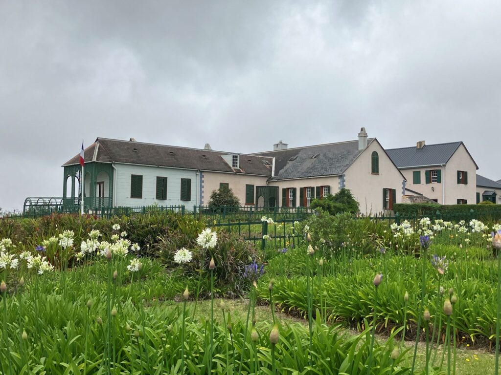
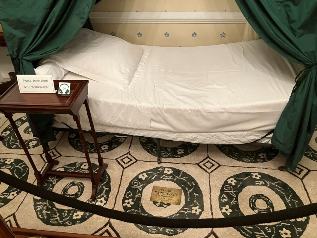
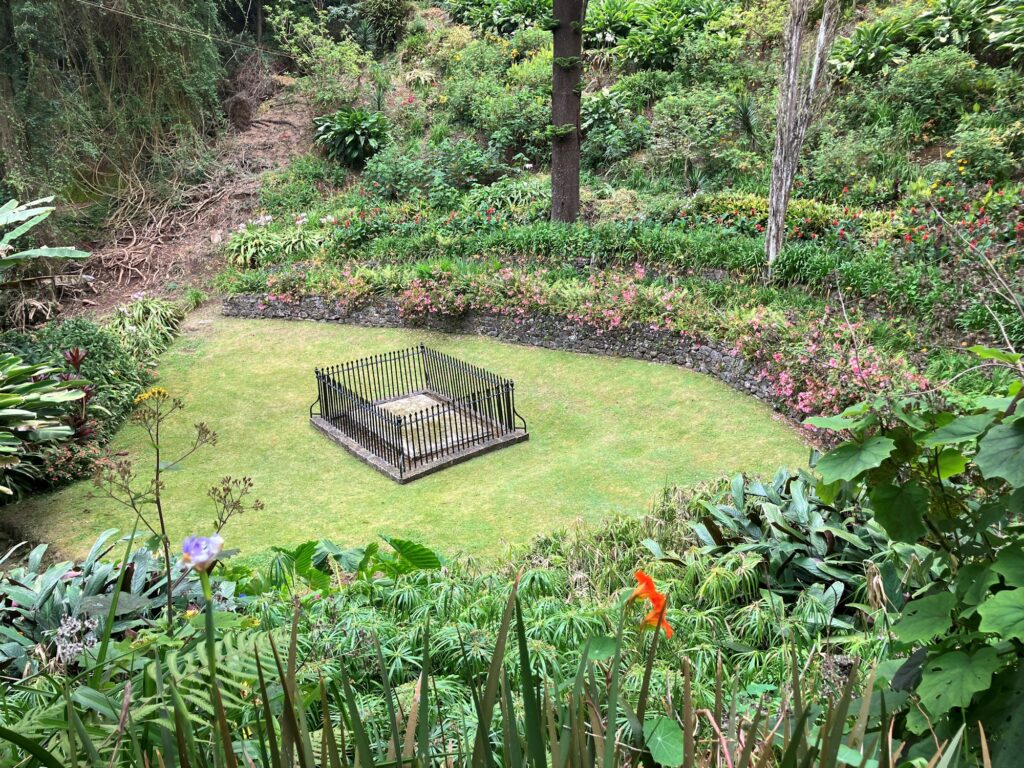
This island is best known as the second exile location of Napoleon, the first exile being on the island of Elba in the Mediterranean which may be best known for the famous palindrome “Able I was ere I saw Elba”. I landed my plane in Elba, which is totally off the topic. Napoleon died on St. Helena in 1821 and was buried there. Through some diplomatic maneuvering, in 1840 the French persuaded the English to let them dig up Napoleon’s tomb and take his remains back to France. They were re-interred at Les Invalides in Paris where they remain today.
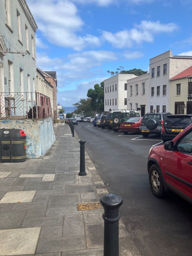
Never inhabited before Europeans arrived, St. Helena was supposedly discovered in 1502 by some Portuguese guy with too many syllables in his name, though some dispute that. Even so, it was in use early on by ships making the journey from Asia back to Europe as a stop for fresh water, timber for repairs and provisions once it was populated with animals. In this way it was similar to La Reunion island I visited this summer, both formed by seamount volcanos. Reunion is much bigger with a population of over 800,000; St. Helena’s population is only about 4,500. Of course, La Reunion is totally French-fried; St. Helena is tout à fait British. British pounds are used here although there is St. Helena money also in circulation on parity with the pound sterling. It’s hard to understand why they’d go to the trouble and expense of having their own currency which is useless elsewhere. They also have local credit cards which are more widely accepted than foreign credit cards like Visa.
Like Namibia, my AT&T cellphone wouldn’t roam onto the local network but I didn’t bother to get a SIM card; I really didn’t need to call anyone. I can’t remember the last place I was where the phone numbers are only 5 digits and the license plates are 4 digits.
I visited all the Napoleon stuff, of course, and took a tour of the island to get a feel for the place during the 4 days I was here. It was mildly interesting. Tourists do come on the weekly flights from Johannesburg to visit these places and also swim with whale sharks. Cruise ships stop for a day about once a month.
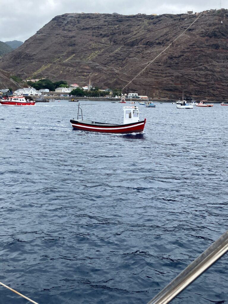
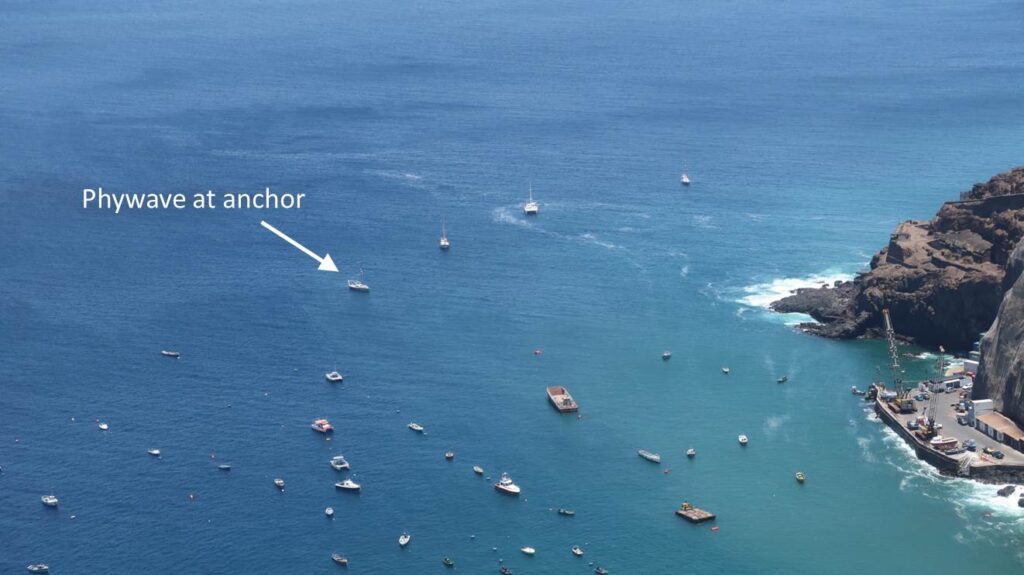
They used to have a popular field of mooring buoys for visiting yachts but they shut it down in January, 2024, because it urgently needed repairs. They say it really needs to be entirely replaced but they don’t have the money to do it. I had to anchor Phywave in 17 meters of water and let out most of my 80 meters of chain. The anchorage is not great, pretty rolly. Fortunately they have a little harbour ferry boat that will pick people up from their anchored yachts and take them to shore, 2.50 pounds return, a bargain.
I did manage to have conversations with a few locals in bars. One guy, a retired fisherman, claimed to have been born on St. Helena and spent most of his life there except for a stint in South Africa. He was slurring his words so I figured he’d already had a lot to drink or maybe he was just talking in cursive. He told me that sometimes the swells and chop in the harbour get so bad the little ferry can’t operate. That’s great, I thought, I need to ride it at least once more to get back to Phywave. Not wanting to dwell on bad boat stories, we changed the subject and he started talking about his family. “My mother started walking 10 miles a day when she turned 65. Now she’s 93 and we have no idea where she is.” Yup.
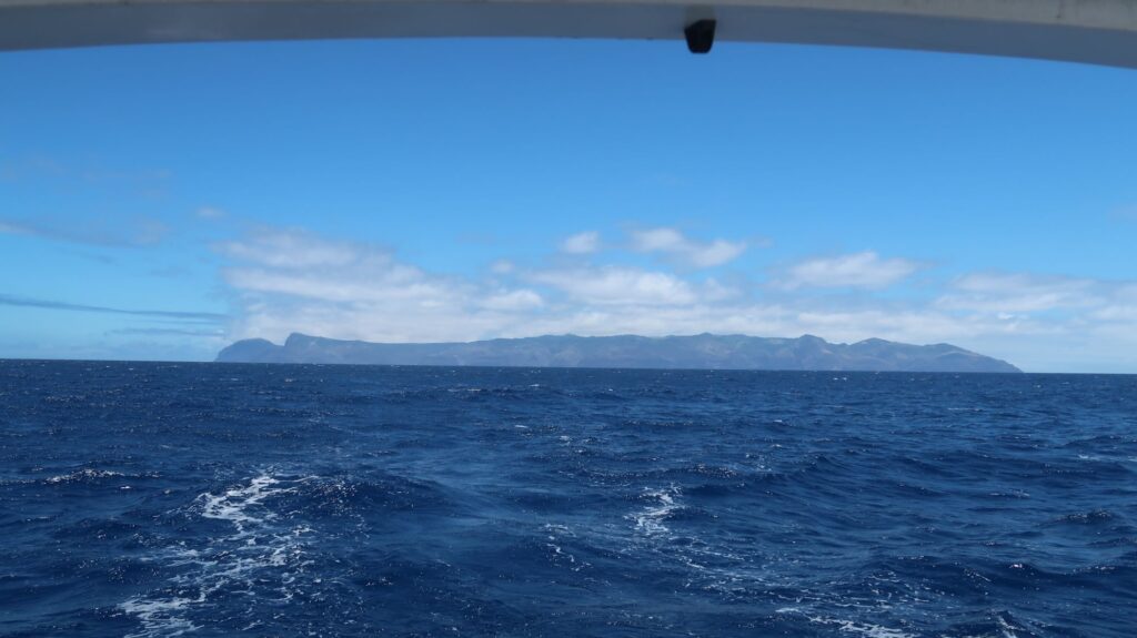
It was time to say goodbye to St. Helena, climb back on my boat, and start sailing northwest. As I watched the island recede over the horizon, I felt sentimental and a bit sad that this voyage was coming to end even though there are still several thousand miles left to sail. From the early planning in 2020, to starting to sail in 2022, until now, if feels like I didn’t savor all the moments enough, that they quickly slipped by. I hope when I write the book about this voyage I can re-capture their fleeting intensity and enduring impact on how I’ve experienced the world.
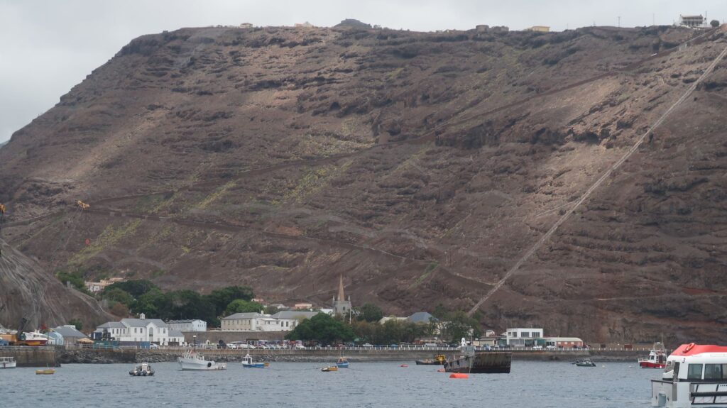
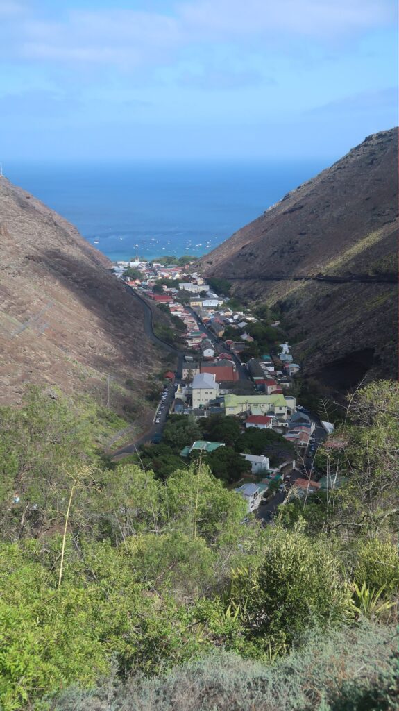
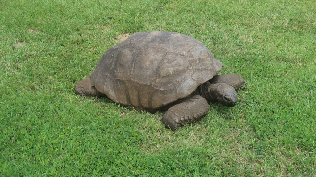
Jamestown from my anchorage. Jacob’s ladder with 699 steep steps in on the right.Jamestown nestled in the valley between 2 mountainsidesSandy Bay on the east side of the islandJonathan the tortoise – 196 years old!The little ferry boat that picks up sailors from their anchored yachts and takes them to shoreMain street in JamestownLongwood house where Napoleon spent his exileNapoleon’s death bedNapoleon’s now empty tombPhywave anchored in James Bay with 3 other visiting yachtsSt. Helena receding over the horizon
I’ve spent almost my entire adult life living on the west coast, very near the Pacific Ocean, and yet I now feel like the Atlantic Ocean is my home ocean since I’ve sailed across it twice and now starting the third time. It seems familiar to me in a way only an ocean sailor can understand.
I am on the homestretch, headed west from Namibia to St. Helena Island, then onward to Antigua and South Florida, the finish line for my solo voyage to 7 continents I can now conceptually see over the horizon to the northwest. I expect to arrive there in early February. From St. Helena I’ll have about 5200 nm left to sail, shorter than my passage from Puerto Montt to the Marquesas.
Until now I kept thinking, generally, “I have a long way to go” without really putting a distance or time frame on it. Buying provisions was affected: I need a lot of food on board because I have a long way to go. I still have many cans of tuna, salmon and vegetables I bought in Chile 18 months ago. I guess I need to start eating more tuna and draw down those reserves instead of buying new stuff because the remaining days are now certainly numbered.
I was reminded of these things this morning when I sailed across the Greenwich Meridian into the Western Hemisphere, definitely my home hemisphere, after spending more than a year on the east side. I’m incrementally getting closer to US time zones so I won’t have to get up in the middle of the night to watch Oregon football games with Starlink. The winds and currents should be favorable for the remaining legs of my voyage, although I’ve learned never to take these things for granted or the mythology of the sea might rise up to smite me. You are well-served by humility when sailing the world’s oceans.
It’s probably not the tag line the Namibia PR people want to see but it’s accurate based on the week I spent here and the parts of the country I saw. There are other places I didn’t see in the north with big game but I do know that Namibia promotes the Namib desert and huge sand dunes as its primary attractions.
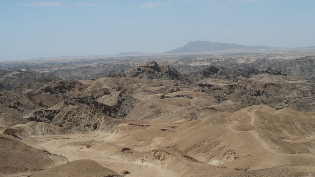
With my boat tied to a great concrete jetty, a 1 km walk from the Walvis Bay Yacht Club facilities, I rented a 4×4 Ranger pickup and headed out, first north to Swakopmund and the Skeleton Coast. Leaving Walvis Bay, the scenery quickly turned to pure desert on both sides of the road which ran parallel to the ocean a couple of hundred meters inland. There’s really nothing to see until Swakopmund.
Swakopmund is regarded here as probably the most attractive town in Namibia. Situated right on the water, it’s a pleasant, walkable place with many restaurants, shops, and hotels, unlike Walvis Bay which is a heavy-duty industrial port town.
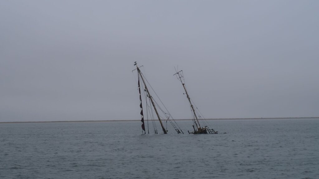
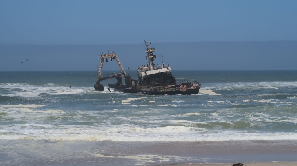
I drove north from Swakopmund along what is known as the Skeleton Coast because of many wrecked ships there over the centuries, and because many dead whales that have washed ashore, their bleached bones sometimes scavenged in the past by local tribes to build huts. Essentially, all the shipwrecks have been so degraded over time there’s nothing left to see. One recent, very visible wreck, the “Zelia”, not far north of Swakopmund, had actually been sold for scrap and was in the process of being towed from Walvis Bay when the tow line broke. It drifted to its current location aground, not because of a navigation error or a storm. A pretty inauspicious shipwreck story.
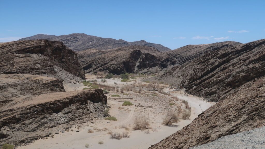
After a night in a Swakopmund hotel I drove over rough gravel roads into the Moon Valley and spent the night at the Goanikontes Oasis, a cluster of bungalows and camping sites among the trees along the river at the bottom of the parched dry Moon Valley. Not a particularly impressive place to stay but the restaurant and bar were OK.
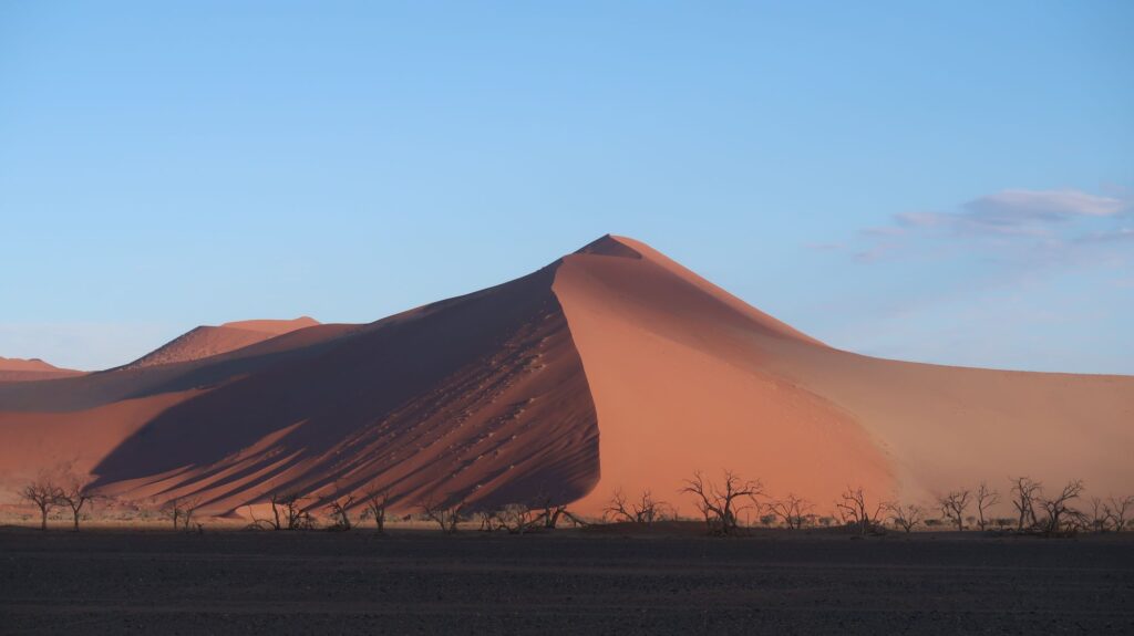
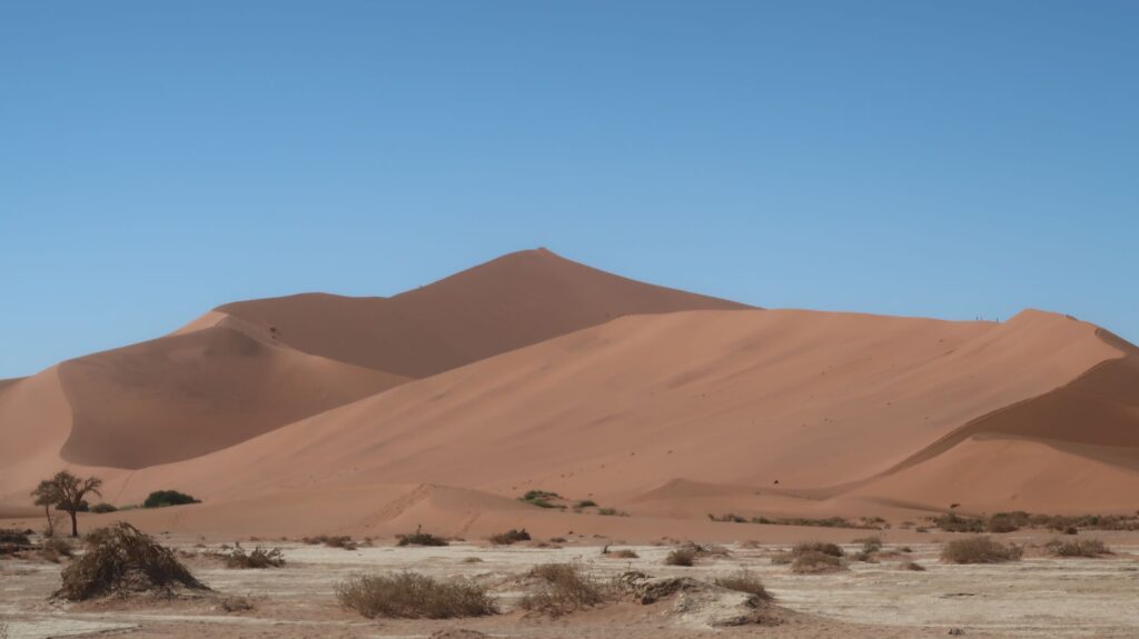
Next I moved on to the “show-stopper” in Namibia, the big red sand dunes of Sossusvlei. It’s about a 300 km drive from Walvis Bay over a road that is only partially paved, the rest being gravel, sometimes very rough washboard gravel, that rattles the bones and the vehicle. I was glad I was driving a 4×4.
From all this driving I had the impression I could have been in many desert landscapes I have known, like driving around Nevada or Arizona. It just wasn’t that different or special. The Moon Valley had exposed rock formations along a river that distinguished it from the flat desert around it but otherwise not particularly noteworthy. Nevertheless, it is definitely promoted as a tourist attraction in Namibia. I came to realize Namibia is being over-promoted in many ways.
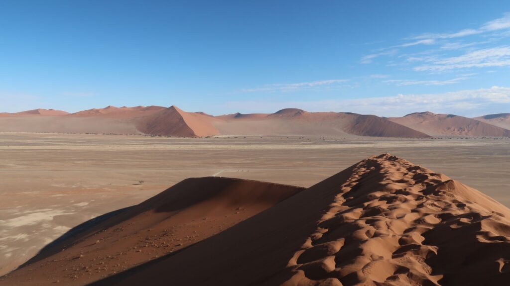
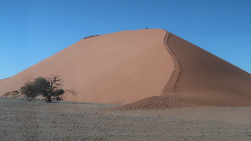
I stayed two nights in the Sossusvlei Lodge, certainly the nicest accommodation near the big sand dunes. I thought I would need a full day to see the place but a half day was enough. The park gate opens at 6 am so everyone is lined up to enter then and see the dunes before it gets too hot. I drove in with the rest, stop at a few viewpoints, then got to Dune 45 (yes, they’re named or numbered). This is a very popular dune to climb so I made the effort. Younger, stronger people passing me going up and down. There really isn’t any opportunity to exercise on the boat so my cardio fitness and basic muscle strength has deteriorated since I started this voyage. But I persevered and made it to the top after a 40 minute climb.
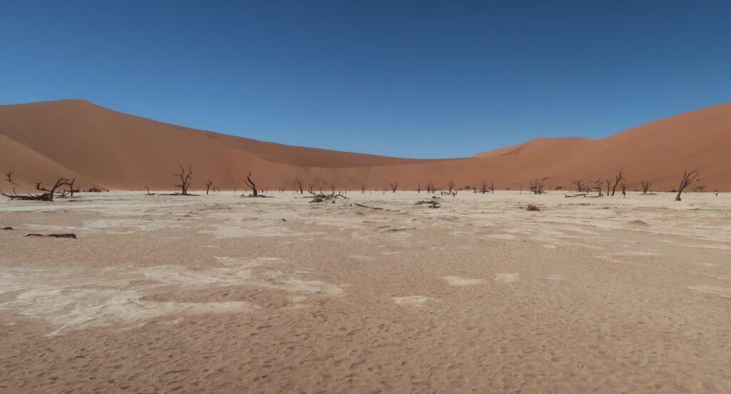
After Dune 45 the road leads farther into the valley to the last 6 km over sand where it’s advisable to take a 4×4 shuttle with an experienced sand driver. Deadvlei is a large, ancient flat pan where water dried up eons ago leaving stark dead trees. It is found at the end of the road after a 1.5 km walk over relatively flat sand. This is also the starting point to climb “Big Daddy”, the largest dune in the park and one of the largest in the world at almost 300 meters tall. After the struggle to climb the smaller Dune 45, there’d be no Big Daddy for me.
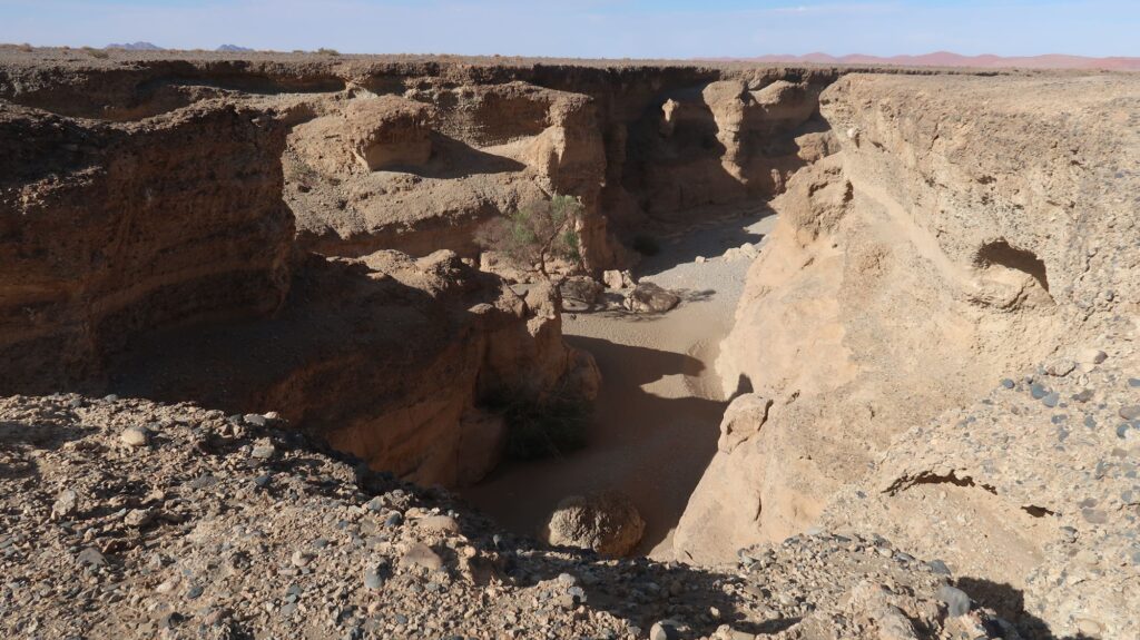
And that’s it. There’s a smaller version of Deadvlei called Hiddenvlei if you want to see it. There is also Sesreim Canyon, a 30 meter deep rocky canyon that runs for about 2 km. Because of shade throughout the day, sometimes water will still pool there attracting animals. None were there when I stopped. Anyway, you can do it all before lunch and before the afternoon heat. Overall, I was disappointed with the place. There are certainly the huge red sand dunes but they’re far away from the road so you don’t get the sense of them looming over you.
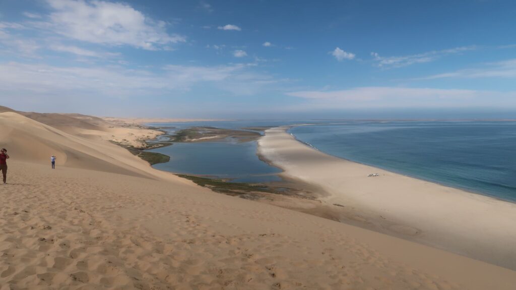
From Sossusvlei I drove back to Walvis Bay along the same poor road. I spent my last morning there, before departure on November 21, on a half day tour south to Sandwich Harbour. That tour is basically a lot of dune driving on big while sand dunes that run down to the sea. I went on this tour mainly to satisfy myself that I had seen it all in terms of what Namibia primarily promotes as their top attractions.
According to a few local tour guides I met along the way, “land of sand” tourism suffers from the poor roads and limited infrastructure. Tour operators from Europe and elsewhere don’t want to send people here and subject them to the bad roads and sparse accommodations.
I’m glad I saw it for myself, though. If you’re in the neighborhood, as I was, it’s worth a visit but I don’t think Namibia is spectacular enough to warrant a special trip just to see it.
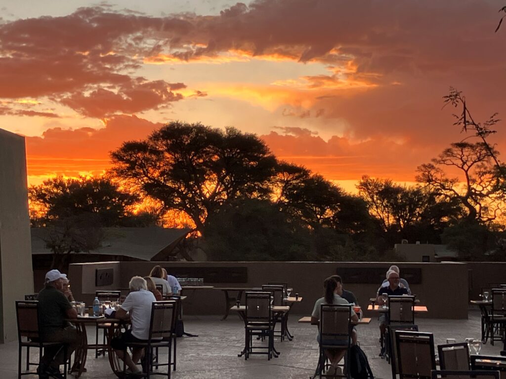
Walvis Bay – this voyage didn’t end so wellZelia shipwreckMoon ValleyDry river bed along the gravel road to SossusvleiDune with shadows from early morning lightFrom the top of Dune 45Beginning of the climb up Dune 45“Big Daddy” sand duneDeadvleiSesreim CanyonSandwich HarbourSunset over the outdoor dining area at Sossusvlei Lodge